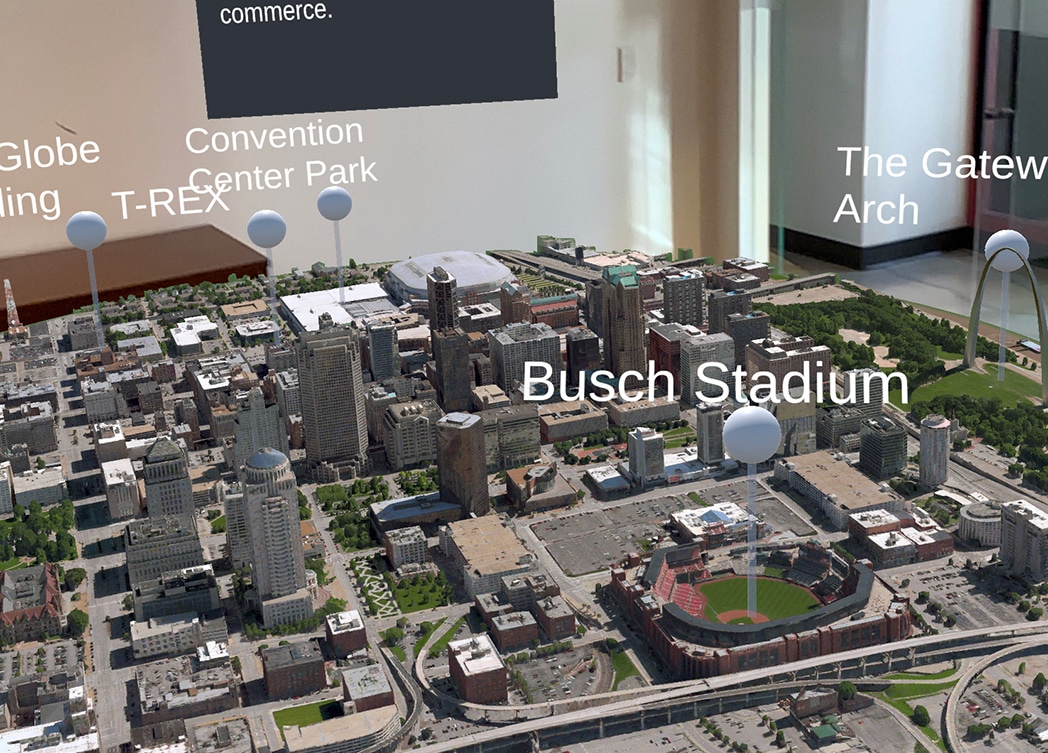
3D GIS Map of Downtown St. Louis
3D GIS City Map with Augmented Reality for a Digital Twin
3D GIS City Map Downtown St. Louis, MO
ARS worked with the T-REX tech incubator to develop a 3D GIS City Map of downtown St. Louis, MO. Furthermore, the app was developed in Unity for augmented reality (AR). This 3D map experience is the building block for a Digital Twin of the region. The mobile application was part of the “GeoDiscovery Experience” at the GEOINT conference. Above all, the app was created to highlight economic vitality within the downtown north insight district in St. Louis, MO.
The talented developer team created an augmented reality (AR) custom application. This digital environment was an exact copy of downtown St. Louis. Furthermore, you can view a virtual 3D city with information overlays within the digital environment. The app utilizes AR city placement to visualize the city virtually in a real life setting.
Key Features of the 3D City
- The 3D map includes a wide area of downtown St. Louis. For example, one view is from the downtown Arch to the Globe building (E to W). In addition, you can see the Arch to the top of convention center (S to N). Furthermore, the T-Rex building and Busch Stadium are highlighted in the experience.
- However, there is one digital representation that was not there for the event! The convention center outdoor addition design was created especially for this event.
- Facts and figures pop up as information overlays within the 3D GIS City Map experience
- The T-Rex building and the Globe building are clickable to zoom into that part of the map. In addition, you can show in greater detail with historic facts, images, and data displayed in 3D
- AR experience developed for a 8’ diameter circle table. However, it can be viewed on any flat surface
- History button on the users screen includes a 3D map on the table. In addition, you can flip the view to show a 2D satellite map on the table as a video
- Easy to use mobile AR app with tutorial. It educates users on how to interact with the 3D GIS Map. This can also be used to illustrate what AR can do.
- In 2D, the video changes over time (decades) of the city and can toggle back to 3D
Challenges and Core Considerations
- The Another Reality Studio project manager began the project with concept evaluation and feasibility. He collaborated with the client on user design, estimating, and planning to create project milestones and a timeline for completion.
- The client asked ARS to develop an application that highlighted the region’s geospatial history and future
- Tight timeline with multiple stakeholders
Impact: The ARS Solution
ARS created a custom application that runs on mobile applications. This application promotes the Downtown North Insight District and the downtown St. Louis map
Application Development
- Interactive AR
- iOS/Android Mobile App Development
AR (Augmented Reality)
- Augmented reality experience
- AR location planning
- Single or multiple product AR visualization
- Real time augmented reality on table top and viewing in AR
Client
Sponsors
AWS, Esri, Downtown North, Globe Building, Leidos, Enterprise, Bayer, Deloitte, World Wide Technology, Ameren, Veritas, Crunchy Data, Freedom Consulting Group, GDIT, Donald Danforth Plant Science Center, Khazaeli Wyrsch
Possible Industries Applications
- Architecture
- Rental or event staging
- Tradeshow/ Conferences
- City Planning/ Design
- Digital Twin
